Drone Analytics Software Market Insights 2025, Analysis and Forecast to 2030, by Manufacturers, Regions, Technology, Application, Product Type
- Single User License (1 Users) $ 3,500
- Team License (2~5 Users) $ 4,500
- Corporate License (>5 Users) $ 5,500
Drone Analytics Software (DAS) is a specialized category of platform and service designed to process, interpret, and derive actionable insights from the vast amounts of visual, thermal, and sensor data collected by Unmanned Aerial Vehicles (UAVs, or drones). This market is characterized by the transformation of raw data—such as high-resolution imagery, LiDAR scans, or infrared readings—into orthomosaic maps, 3D models, point clouds, and automated defect reports. DAS is an essential bridge, converting the drone's capability as a data collection tool into a reliable source of business intelligence across numerous vertical industries.
The industry's core features are its reliance on advanced computer vision, machine learning (ML), and artificial intelligence (AI) to automate data analysis and flagging, moving away from manual inspection. It is highly multidisciplinary, integrating with established enterprise systems like GIS (Geographic Information Systems), BIM (Building Information Modeling), and asset management platforms. Key drivers include the proven efficiency gains over traditional inspection methods, the reduction in safety risks (especially in complex industrial environments like solar farms or oil & gas facilities), and the continuous decrease in the cost and complexity of high-quality drone hardware. The DAS market is highly scalable, serving sectors that require frequent, precise, and large-area data capture.
The global market size for Drone Analytics Software, including licensing, subscription fees, and cloud processing services, is estimated to fall within the range of USD 1.0 billion and USD 3.0 billion by 2025. This valuation reflects the rapid transition of industries from proof-of-concept trials to large-scale operational deployment. The market is projected to expand at a robust Compound Annual Growth Rate (CAGR) of approximately 7.0% to 17.0% through 2030. This strong growth is driven by regulatory approvals enabling beyond-visual-line-of-sight (BVLOS) operations and the maturation of AI-powered automated reporting tools.
Segment Analysis: Deployment Model and Key Applications
The functionality of Drone Analytics Software is often segmented by how the data is processed and the specific insights derived.
By Deployment Model
Cloud-Based
Cloud-Based DAS is the dominant and fastest-growing segment, projected to experience a CAGR in the range of 8.0%–19.0%. This model offers superior scalability, flexibility, and computational power, allowing users to upload vast datasets for rapid processing without requiring significant local computing resources. It facilitates collaboration, enabling remote teams to access and analyze the same data instantly. Cloud deployment is preferred by smaller to mid-sized enterprises and large corporations seeking efficient data storage, version control, and seamless integration with other Software-as-a-Service (SaaS) tools.
On-Premises
The On-Premises deployment model involves installing the DAS software directly onto a user's dedicated server infrastructure, projected to grow at a more moderate CAGR in the range of 5.0%–13.0%. This approach is favored by sectors with stringent data security or regulatory requirements, such as defense, government agencies, and critical infrastructure (e.g., nuclear power plants). It ensures that highly sensitive data remains within the organization’s firewall. Furthermore, organizations managing extremely high data volumes or requiring low latency (near-real-time processing) often opt for on-premises solutions or a hybrid model.
By Application
3D Modelling and Volumetric Calculations
This category is essential for the construction, mining, and aggregates industries, enabling the creation of accurate digital twins, cut/fill analysis, and measuring stockpile volumes with high precision. This application segment is projected for the highest growth, estimated at a CAGR in the range of 9.0%–18.0%, as it directly translates data into substantial cost savings and project efficiency improvements by replacing manual surveying.
Aerial Monitoring and Geolocation Tagging
This broad application covers tasks like infrastructure inspection (power lines, railways), security surveillance, environmental monitoring, and site progress tracking in construction. It involves generating orthomosaic maps and tagging assets with precise geographic coordinates. Growth is projected in the range of 7.0%–16.0% CAGR, driven by the need for routine, safe, and cost-effective monitoring of distributed assets across wide geographies.
Thermal Detection
Thermal analysis is critical for inspecting solar farms, utility components, building envelopes, and oil & gas pipelines to identify equipment faults, leakage, or insulation issues invisible to the naked eye. The specialized nature and high value of the insights provided by this application result in projected growth in the range of 6.5%–15.5% CAGR, particularly tied to the expansion of renewable energy infrastructure globally.
Regional Market Trends
Regional market growth is primarily dictated by the local regulatory environment regarding drone operations and the maturity of core industries that are major DAS users (construction, mining, agriculture, energy).
Asia-Pacific (APAC)
APAC is anticipated to be the most rapidly expanding region, projected to achieve a strong CAGR in the range of 8.0%–19.0%. This growth is fueled by massive infrastructure and construction projects (particularly in China, India, and Southeast Asia), high adoption rates in precision agriculture, and the widespread use of drones in mining and energy sectors. Favorable government policies promoting digital construction and smart city development are accelerating the adoption of DAS platforms.
North America (NA)
North America holds the largest current market share, benefiting from early adoption and robust enterprise spending, with projected growth in the range of 7.0%–17.0% CAGR. The market is mature, driven by advanced regulatory frameworks (FAA in the US) that, while strict, provide clear pathways for commercial operations. Key drivers include the US oil & gas sector, advanced construction sites, and highly automated agriculture. Demand is focused on sophisticated AI integration and regulatory compliance features.
Europe
Europe is a strong, stable market, with growth projected in the range of 7.5%–17.0% CAGR. The region benefits from unified safety regulations (EASA) that are steadily easing restrictions, opening up more airspace for commercial operations. Key market drivers include the inspection of complex industrial facilities, cultural heritage preservation, and the rapidly growing offshore wind energy sector, which heavily relies on drone data for structural integrity analysis.
Latin America (LatAm)
The LatAm market is characterized by significant opportunities in mining, large-scale agriculture (e.g., Brazil, Argentina), and infrastructure development. Growth is projected in the range of 6.5%–15.5% CAGR. Adoption is generally accelerating, although often constrained by fragmented or evolving regulatory frameworks and slower digital transformation rates in some public sectors.
Middle East and Africa (MEA)
MEA is emerging strongly, driven by substantial investment in oil & gas, megaprojects (e.g., Saudi Arabia, UAE), and security applications. Growth is projected in the range of 6.0%–15.0% CAGR. The region’s focus on rapidly deploying infrastructure and security measures makes DAS a natural fit for project monitoring and surveillance, though the market size remains smaller than in developed regions.
Company Landscape: Software Specialization and Ecosystems
The Drone Analytics Software market features a mix of pure-play software developers and specialized enterprise data integrators, often competing via ecosystem development and vertical market expertise.
Dedicated Software Platforms: Companies like DroneDeploy Inc., Pix4D SA, and Propeller Aero Inc. are pure-play DAS providers. DroneDeploy is recognized for its broad, user-friendly cloud-based platform and large app marketplace, targeting construction and agriculture. Pix4D specializes in highly accurate photogrammetry software, favored by surveying and mapping professionals. Propeller Aero focuses intensely on the construction and mining verticals, specializing in site surveying and earthwork management solutions that tie directly into heavy equipment workflows.
Enterprise Solution Integrators: ESRI Inc. is a dominant player, leveraging its ubiquitous GIS platform to provide powerful spatial analysis capabilities to drone data, integrating it with existing enterprise maps and databases. PrecisionHawk Inc. and Delair often focus on providing end-to-end solutions, combining proprietary software with specialized drones for high-stakes industrial inspection tasks, particularly in energy and utility sectors.
Niche and Application Specialists: Companies like Kespry Inc., Skycatch Inc., EagleNXT, and DroneBase Inc. frequently target deep vertical specialization. Kespry provides a fully integrated solution for aggregates and mining. Skycatch focuses on automating large-scale construction site data capture and analytics. DroneBase primarily offers data acquisition services alongside its processing platform, bridging the gap between raw data collection and final analysis.
Industry Value Chain Analysis
The value chain for Drone Analytics Software is centered on converting the efficiency of drone hardware into measurable, actionable business intelligence for enterprise consumption.
1. Data Acquisition (Upstream):
The chain begins with the Drone/Sensor Manufacturers (e.g., DJI, senseFly, specialized sensor makers) who provide the hardware capable of capturing the necessary high-fidelity data (RGB, thermal, LiDAR). Value creation at this stage is hardware reliability, flight planning efficiency, and sensor quality.
2. Raw Data Management (Midstream):
The collected raw data (hundreds of gigabytes per flight) is transferred to the Drone Analytics Software Platform (DAS) via cloud upload or physical hard drive. The software’s initial value is in cleaning, stitching, and geo-referencing the raw images and sensor readings into usable formats like orthomosaics or point clouds.
3. Insight Generation (Core Value):
This is the heart of the DAS market. The software (DroneDeploy, Pix4D, Propeller) applies sophisticated AI/ML algorithms to automatically analyze the data. This includes defect detection (e.g., crack identification on a wind turbine), change detection (e.g., monitoring construction progress), and mathematical processing (e.g., volumetric calculations). Value is generated by automating tasks that previously required human hours and expertise, delivering faster, more objective reports.
4. Enterprise Integration and Delivery (Downstream):
The generated insights and reports are integrated into the client's existing workflows, often via APIs or direct plugins with GIS/BIM/ERP systems (ESRI). The final report is delivered to the End-User (site manager, engineer, insurer) who uses the information to make a critical business decision, such as signing off on a stage of construction or dispatching a repair team. Downstream value is realized in the measurable improvement of business outcomes (cost reduction, risk mitigation, faster project delivery).
Opportunities and Challenges
The DAS market’s future is dependent on its ability to overcome regulatory hurdles and achieve deep integration into legacy enterprise workflows.
Opportunities
Regulatory Simplification (BVLOS and Autonomy): The easing of aviation regulations worldwide, particularly permitting routine Beyond Visual Line of Sight (BVLOS) operations, is a massive catalyst. This shift dramatically reduces the operational cost of data collection over long distances (e.g., pipelines, railways) and opens up opportunities for truly autonomous, scheduled data capture that powers DAS platforms.
Digital Twin and BIM Integration: The increasing use of Digital Twins in construction and industrial sectors creates a persistent, high-value demand for DAS, which serves as the primary engine for updating the Twin with real-world, real-time data. Tighter integration with Building Information Modeling (BIM) software is a key area for high-margin service growth.
Edge Computing and Real-Time Analysis: The development of more powerful, smaller processors allows for initial data processing (e.g., quality checks, immediate anomaly detection) to occur on the drone (at the edge). This reduces the data transmission burden and enables near-real-time actionable insights, critical for emergency response or rapid inspection scenarios.
Vertical Specialization and Custom AI Models: As the market matures, there is an increasing opportunity for vendors to develop highly specialized, proprietary AI models trained exclusively on specific asset types (e.g., cell towers, specific crop diseases, bridge structures). This deep specialization generates superior accuracy and higher customer lock-in.
Challenges
Data Security and Management: Drone datasets are massive and often contain sensitive infrastructure or site-specific intellectual property. Ensuring secure data transmission, storage, and access control for both cloud and on-premises solutions poses a continuous technical and legal challenge, particularly when dealing with government or critical infrastructure clients.
Talent Scarcity and Skill Gap: The effective deployment of DAS requires a highly specific skill set combining drone operation, data science, and domain expertise (e.g., civil engineering or agronomy). The lack of a large, available workforce proficient in all three areas creates a bottleneck in adoption for many end-user organizations.
Standardization and Interoperability: A lack of common, universal data formats and output standards across different DAS vendors and hardware types complicates data sharing and integration. Enterprise users often face difficulty integrating data from multiple drone programs into a single, unified GIS or ERP system, hindering large-scale implementation.
High Initial Investment Barrier: Although drone hardware costs are falling, the cost of implementing a full enterprise drone program—including regulatory compliance, pilot training, and the annual subscription for advanced DAS—still represents a significant initial capital expenditure that can deter small and medium-sized enterprises.
Chapter 1 Executive Summary
Chapter 2 Abbreviation and Acronyms
Chapter 3 Preface
3.1 Research Scope
3.2 Research Sources
3.2.1 Data Sources
3.2.2 Assumptions
3.3 Research Method
Chapter 4 Market Landscape
4.1 Market Overview
4.2 Classification/Types
4.3 Application/End Users
Chapter 5 Market Trend Analysis
5.1 introduction
5.2 Drivers
5.3 Restraints
5.4 Opportunities
5.5 Threats
Chapter 6 industry Chain Analysis
6.1 Upstream/Suppliers Analysis
6.2 Drone Analytics Software Analysis
6.2.1 Technology Analysis
6.2.2 Cost Analysis
6.2.3 Market Channel Analysis
6.3 Downstream Buyers/End Users
Chapter 7 Latest Market Dynamics
7.1 Latest News
7.2 Merger and Acquisition
7.3 Planned/Future Project
7.4 Policy Dynamics
Chapter 8 Historical and Forecast Drone Analytics Software Market in North America (2020-2030)
8.1 Drone Analytics Software Market Size
8.2 Drone Analytics Software Market by End Use
8.3 Competition by Players/Suppliers
8.4 Drone Analytics Software Market Size by Type
8.5 Key Countries Analysis
8.5.1 United States
8.5.2 Canada
8.5.3 Mexico
Chapter 9 Historical and Forecast Drone Analytics Software Market in South America (2020-2030)
9.1 Drone Analytics Software Market Size
9.2 Drone Analytics Software Market by End Use
9.3 Competition by Players/Suppliers
9.4 Drone Analytics Software Market Size by Type
9.5 Key Countries Analysis
9.5.1 Brazil
9.5.2 Argentina
9.5.3 Chile
9.5.4 Peru
Chapter 10 Historical and Forecast Drone Analytics Software Market in Asia & Pacific (2020-2030)
10.1 Drone Analytics Software Market Size
10.2 Drone Analytics Software Market by End Use
10.3 Competition by Players/Suppliers
10.4 Drone Analytics Software Market Size by Type
10.5 Key Countries Analysis
10.5.1 China
10.5.2 India
10.5.3 Japan
10.5.4 South Korea
10.5.5 Southest Asia
10.5.6 Australia
Chapter 11 Historical and Forecast Drone Analytics Software Market in Europe (2020-2030)
11.1 Drone Analytics Software Market Size
11.2 Drone Analytics Software Market by End Use
11.3 Competition by Players/Suppliers
11.4 Drone Analytics Software Market Size by Type
11.5 Key Countries Analysis
11.5.1 Germany
11.5.2 France
11.5.3 United Kingdom
11.5.4 Italy
11.5.5 Spain
11.5.6 Belgium
11.5.7 Netherlands
11.5.8 Austria
11.5.9 Poland
11.5.10 Russia
Chapter 12 Historical and Forecast Drone Analytics Software Market in MEA (2020-2030)
12.1 Drone Analytics Software Market Size
12.2 Drone Analytics Software Market by End Use
12.3 Competition by Players/Suppliers
12.4 Drone Analytics Software Market Size by Type
12.5 Key Countries Analysis
12.5.1 Egypt
12.5.2 Israel
12.5.3 South Africa
12.5.4 Gulf Cooperation Council Countries
12.5.5 Turkey
Chapter 13 Summary For Global Drone Analytics Software Market (2020-2025)
13.1 Drone Analytics Software Market Size
13.2 Drone Analytics Software Market by End Use
13.3 Competition by Players/Suppliers
13.4 Drone Analytics Software Market Size by Type
Chapter 14 Global Drone Analytics Software Market Forecast (2025-2030)
14.1 Drone Analytics Software Market Size Forecast
14.2 Drone Analytics Software Application Forecast
14.3 Competition by Players/Suppliers
14.4 Drone Analytics Software Type Forecast
Chapter 15 Analysis of Global Key Vendors
15.1 DroneDeploy Inc.
15.1.1 Company Profile
15.1.2 Main Business and Drone Analytics Software Information
15.1.3 SWOT Analysis of DroneDeploy Inc.
15.1.4 DroneDeploy Inc. Drone Analytics Software Sales, Revenue, Price and Gross Margin (2020-2025)
15.2 Pix4D SA
15.2.1 Company Profile
15.2.2 Main Business and Drone Analytics Software Information
15.2.3 SWOT Analysis of Pix4D SA
15.2.4 Pix4D SA Drone Analytics Software Sales, Revenue, Price and Gross Margin (2020-2025)
15.3 PrecisionHawk Inc.
15.3.1 Company Profile
15.3.2 Main Business and Drone Analytics Software Information
15.3.3 SWOT Analysis of PrecisionHawk Inc.
15.3.4 PrecisionHawk Inc. Drone Analytics Software Sales, Revenue, Price and Gross Margin (2020-2025)
15.4 ESRI Inc.
15.4.1 Company Profile
15.4.2 Main Business and Drone Analytics Software Information
15.4.3 SWOT Analysis of ESRI Inc.
15.4.4 ESRI Inc. Drone Analytics Software Sales, Revenue, Price and Gross Margin (2020-2025)
15.5 Kespry Inc.
15.5.1 Company Profile
15.5.2 Main Business and Drone Analytics Software Information
15.5.3 SWOT Analysis of Kespry Inc.
15.5.4 Kespry Inc. Drone Analytics Software Sales, Revenue, Price and Gross Margin (2020-2025)
15.6 Propeller Aero Inc.
15.6.1 Company Profile
15.6.2 Main Business and Drone Analytics Software Information
15.6.3 SWOT Analysis of Propeller Aero Inc.
15.6.4 Propeller Aero Inc. Drone Analytics Software Sales, Revenue, Price and Gross Margin (2020-2025)
Please ask for sample pages for full companies list
Table Research Scope of Drone Analytics Software Report
Table Data Sources of Drone Analytics Software Report
Table Major Assumptions of Drone Analytics Software Report
Table Drone Analytics Software Classification
Table Drone Analytics Software Applications
Table Drivers of Drone Analytics Software Market
Table Restraints of Drone Analytics Software Market
Table Opportunities of Drone Analytics Software Market
Table Threats of Drone Analytics Software Market
Table Raw Materials Suppliers
Table Different Production Methods of Drone Analytics Software
Table Cost Structure Analysis of Drone Analytics Software
Table Key End Users
Table Latest News of Drone Analytics Software Market
Table Merger and Acquisition
Table Planned/Future Project of Drone Analytics Software Market
Table Policy of Drone Analytics Software Market
Table 2020-2030 North America Drone Analytics Software Market Size
Table 2020-2030 North America Drone Analytics Software Market Size by Application
Table 2020-2025 North America Drone Analytics Software Key Players Revenue
Table 2020-2025 North America Drone Analytics Software Key Players Market Share
Table 2020-2030 North America Drone Analytics Software Market Size by Type
Table 2020-2030 United States Drone Analytics Software Market Size
Table 2020-2030 Canada Drone Analytics Software Market Size
Table 2020-2030 Mexico Drone Analytics Software Market Size
Table 2020-2030 South America Drone Analytics Software Market Size
Table 2020-2030 South America Drone Analytics Software Market Size by Application
Table 2020-2025 South America Drone Analytics Software Key Players Revenue
Table 2020-2025 South America Drone Analytics Software Key Players Market Share
Table 2020-2030 South America Drone Analytics Software Market Size by Type
Table 2020-2030 Brazil Drone Analytics Software Market Size
Table 2020-2030 Argentina Drone Analytics Software Market Size
Table 2020-2030 Chile Drone Analytics Software Market Size
Table 2020-2030 Peru Drone Analytics Software Market Size
Table 2020-2030 Asia & Pacific Drone Analytics Software Market Size
Table 2020-2030 Asia & Pacific Drone Analytics Software Market Size by Application
Table 2020-2025 Asia & Pacific Drone Analytics Software Key Players Revenue
Table 2020-2025 Asia & Pacific Drone Analytics Software Key Players Market Share
Table 2020-2030 Asia & Pacific Drone Analytics Software Market Size by Type
Table 2020-2030 China Drone Analytics Software Market Size
Table 2020-2030 India Drone Analytics Software Market Size
Table 2020-2030 Japan Drone Analytics Software Market Size
Table 2020-2030 South Korea Drone Analytics Software Market Size
Table 2020-2030 Southeast Asia Drone Analytics Software Market Size
Table 2020-2030 Australia Drone Analytics Software Market Size
Table 2020-2030 Europe Drone Analytics Software Market Size
Table 2020-2030 Europe Drone Analytics Software Market Size by Application
Table 2020-2025 Europe Drone Analytics Software Key Players Revenue
Table 2020-2025 Europe Drone Analytics Software Key Players Market Share
Table 2020-2030 Europe Drone Analytics Software Market Size by Type
Table 2020-2030 Germany Drone Analytics Software Market Size
Table 2020-2030 France Drone Analytics Software Market Size
Table 2020-2030 United Kingdom Drone Analytics Software Market Size
Table 2020-2030 Italy Drone Analytics Software Market Size
Table 2020-2030 Spain Drone Analytics Software Market Size
Table 2020-2030 Belgium Drone Analytics Software Market Size
Table 2020-2030 Netherlands Drone Analytics Software Market Size
Table 2020-2030 Austria Drone Analytics Software Market Size
Table 2020-2030 Poland Drone Analytics Software Market Size
Table 2020-2030 Russia Drone Analytics Software Market Size
Table 2020-2030 MEA Drone Analytics Software Market Size
Table 2020-2030 MEA Drone Analytics Software Market Size by Application
Table 2020-2025 MEA Drone Analytics Software Key Players Revenue
Table 2020-2025 MEA Drone Analytics Software Key Players Market Share
Table 2020-2030 MEA Drone Analytics Software Market Size by Type
Table 2020-2030 Egypt Drone Analytics Software Market Size
Table 2020-2030 Israel Drone Analytics Software Market Size
Table 2020-2030 South Africa Drone Analytics Software Market Size
Table 2020-2030 Gulf Cooperation Council Countries Drone Analytics Software Market Size
Table 2020-2030 Turkey Drone Analytics Software Market Size
Table 2020-2025 Global Drone Analytics Software Market Size by Region
Table 2020-2025 Global Drone Analytics Software Market Size Share by Region
Table 2020-2025 Global Drone Analytics Software Market Size by Application
Table 2020-2025 Global Drone Analytics Software Market Share by Application
Table 2020-2025 Global Drone Analytics Software Key Vendors Revenue
Table 2020-2025 Global Drone Analytics Software Key Vendors Market Share
Table 2020-2025 Global Drone Analytics Software Market Size by Type
Table 2020-2025 Global Drone Analytics Software Market Share by Type
Table 2025-2030 Global Drone Analytics Software Market Size by Region
Table 2025-2030 Global Drone Analytics Software Market Size Share by Region
Table 2025-2030 Global Drone Analytics Software Market Size by Application
Table 2025-2030 Global Drone Analytics Software Market Share by Application
Table 2025-2030 Global Drone Analytics Software Key Vendors Revenue
Table 2025-2030 Global Drone Analytics Software Key Vendors Market Share
Table 2025-2030 Global Drone Analytics Software Market Size by Type
Table 2025-2030 Drone Analytics Software Global Market Share by Type
Figure Market Size Estimated Method
Figure Major Forecasting Factors
Figure Drone Analytics Software Picture
Figure 2020-2030 North America Drone Analytics Software Market Size and CAGR
Figure 2020-2030 South America Drone Analytics Software Market Size and CAGR
Figure 2020-2030 Asia & Pacific Drone Analytics Software Market Size and CAGR
Figure 2020-2030 Europe Drone Analytics Software Market Size and CAGR
Figure 2020-2030 MEA Drone Analytics Software Market Size and CAGR
Figure 2020-2025 Global Drone Analytics Software Market Size and Growth Rate
Figure 2025-2030 Global Drone Analytics Software Market Size and Growth Rate
Research Methodology
- Market Estimated Methodology:
Bottom-up & top-down approach, supply & demand approach are the most important method which is used by HDIN Research to estimate the market size.
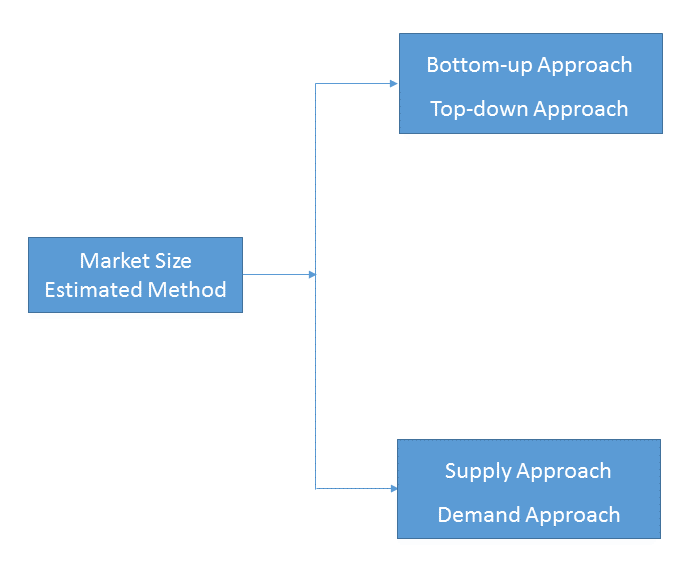
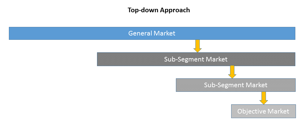
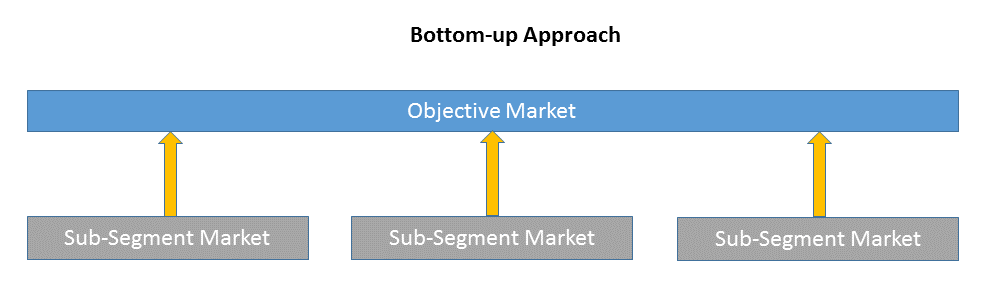
1)Top-down & Bottom-up Approach
Top-down approach uses a general market size figure and determines the percentage that the objective market represents.
Bottom-up approach size the objective market by collecting the sub-segment information.
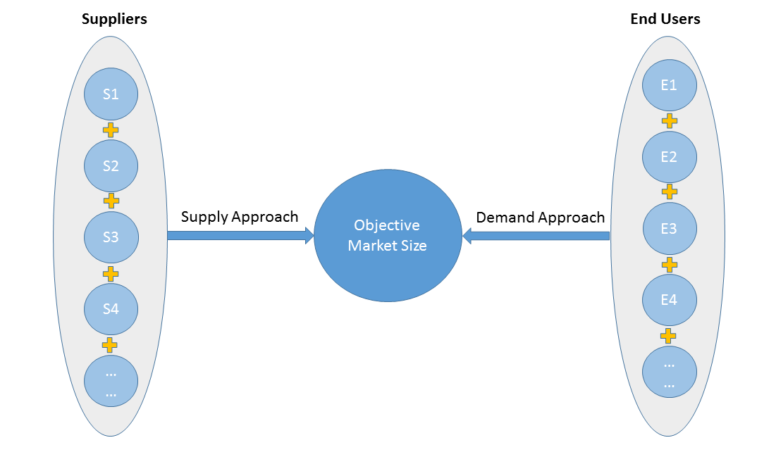
2)Supply & Demand Approach
Supply approach is based on assessments of the size of each competitor supplying the objective market.
Demand approach combine end-user data within a market to estimate the objective market size. It is sometimes referred to as bottom-up approach.
- Forecasting Methodology
- Numerous factors impacting the market trend are considered for forecast model:
- New technology and application in the future;
- New project planned/under contraction;
- Global and regional underlying economic growth;
- Threatens of substitute products;
- Industry expert opinion;
- Policy and Society implication.
- Analysis Tools
1)PEST Analysis
PEST Analysis is a simple and widely used tool that helps our client analyze the Political, Economic, Socio-Cultural, and Technological changes in their business environment.
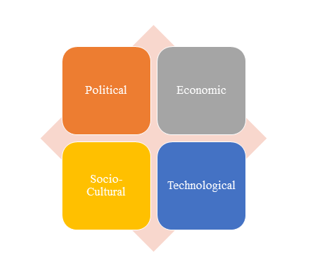
- Benefits of a PEST analysis:
- It helps you to spot business opportunities, and it gives you advanced warning of significant threats.
- It reveals the direction of change within your business environment. This helps you shape what you’re doing, so that you work with change, rather than against it.
- It helps you avoid starting projects that are likely to fail, for reasons beyond your control.
- It can help you break free of unconscious assumptions when you enter a new country, region, or market; because it helps you develop an objective view of this new environment.
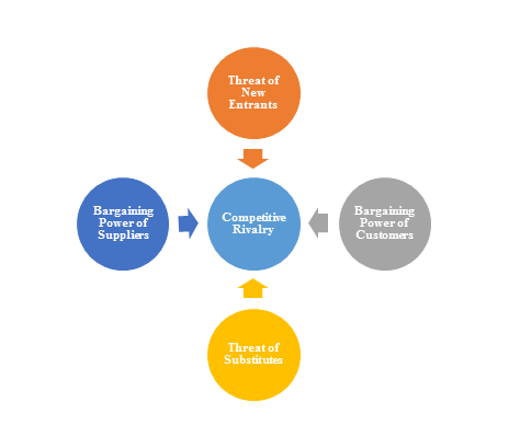
2)Porter’s Five Force Model Analysis
The Porter’s Five Force Model is a tool that can be used to analyze the opportunities and overall competitive advantage. The five forces that can assist in determining the competitive intensity and potential attractiveness within a specific area.
- Threat of New Entrants: Profitable industries that yield high returns will attract new firms.
- Threat of Substitutes: A substitute product uses a different technology to try to solve the same economic need.
- Bargaining Power of Customers: the ability of customers to put the firm under pressure, which also affects the customer's sensitivity to price changes.
- Bargaining Power of Suppliers: Suppliers of raw materials, components, labor, and services (such as expertise) to the firm can be a source of power over the firm when there are few substitutes.
- Competitive Rivalry: For most industries the intensity of competitive rivalry is the major determinant of the competitiveness of the industry.
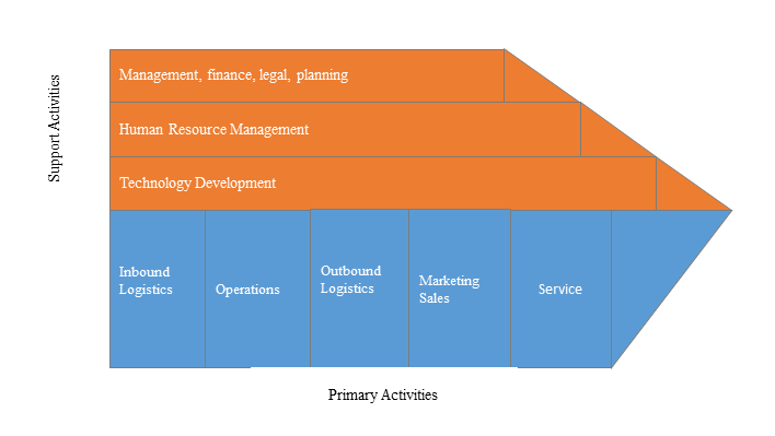
3)Value Chain Analysis
Value chain analysis is a tool to identify activities, within and around the firm and relating these activities to an assessment of competitive strength. Value chain can be analyzed by primary activities and supportive activities. Primary activities include: inbound logistics, operations, outbound logistics, marketing & sales, service. Support activities include: technology development, human resource management, management, finance, legal, planning.
4)SWOT Analysis
SWOT analysis is a tool used to evaluate a company's competitive position by identifying its strengths, weaknesses, opportunities and threats. The strengths and weakness is the inner factor; the opportunities and threats are the external factor. By analyzing the inner and external factors, the analysis can provide the detail information of the position of a player and the characteristics of the industry.
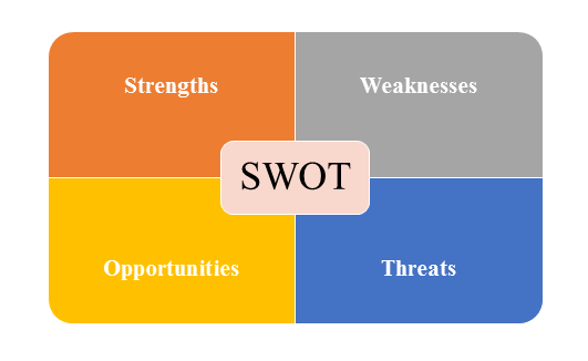
- Strengths describe what the player excels at and separates it from the competition
- Weaknesses stop the player from performing at its optimum level.
- Opportunities refer to favorable external factors that the player can use to give it a competitive advantage.
- Threats refer to factors that have the potential to harm the player.
- Data Sources
| Primary Sources | Secondary Sources |
|---|---|
| Face to face/Phone Interviews with market participants, such as: Manufactures; Distributors; End-users; Experts. Online Survey |
Government/International Organization Data: Annual Report/Presentation/Fact Book Internet Source Information Industry Association Data Free/Purchased Database Market Research Report Book/Journal/News |